
For a long time, I have been a Ride With GPS user for planning out touring routes, which I then exported to my Garmin Edge 1030 for use on the bike. I do not tend to use the RWGPS phone app. I tended to pay for a month's premium membership as needed.
I have just started exploring Koomot but have yet to purchase a year's premium membership, which is currently discounted to USD $ 29.99 for the first year.
I am yet to decide whether to stick with RWGPS or move to Koomot. The collections feature in Koomot is particularly appealing.
I would value your thoughts if you have experience with Koomot or both.
Koomot v Ride With GPS
-
Aushiker

- Posts: 22402
- Joined: Tue Jun 05, 2007 1:55 pm
- Location: Walyalup land
- Contact:
-
RonK

- Posts: 11508
- Joined: Mon Aug 24, 2009 2:08 pm
- Location: If you need to know, ask me
- Contact:
Re: Koomot v Ride With GPS
As a long time RWGPS user I have considered Koomoot but it doesn't really appeal. Nor does Gaia.
RWGPS also has a collections feature and I have used it for several longer multi-stage trips.
RWGPS also has a collections feature and I have used it for several longer multi-stage trips.
Cycle touring blog and tour journals: whispering wheels...
-
Aushiker
- Posts: 22402
- Joined: Tue Jun 05, 2007 1:55 pm
- Location: Walyalup land
- Contact:
Re: Koomot v Ride With GPS
I am also a long-time RWGPS user, having spent some time playing with Komoot. I am inclined to stick with RWGPS and export my hikes to Komoot for synchronisation with my watch, but otherwise, I will use RWGPS.
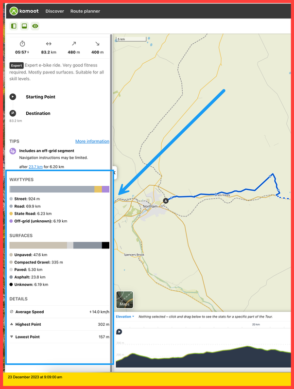
The one thing I particularly like about Komoot is the presentation of tour profile it provides. I think you can see the details provided at https://www.komoot.com/tour/1396062807.
The one thing I particularly like about Komoot is the presentation of tour profile it provides. I think you can see the details provided at https://www.komoot.com/tour/1396062807.
Andrew
Aushiker.com
Aushiker.com
-
RonK
- Posts: 11508
- Joined: Mon Aug 24, 2009 2:08 pm
- Location: If you need to know, ask me
- Contact:
Re: Koomot v Ride With GPS
If you are referring to the elevation profile summary then RWGPS has all this and also shows where the route is paved and unpaved - very useful to me as I seek out gravel routes.
Cycle touring blog and tour journals: whispering wheels...
-
Aushiker
- Posts: 22402
- Joined: Tue Jun 05, 2007 1:55 pm
- Location: Walyalup land
- Contact:
Re: Koomot v Ride With GPS
It was more about the presentation of the other information. Not so nice in RWGPS.
 how to screenshot on windows 7
how to screenshot on windows 7Andrew
Aushiker.com
Aushiker.com
-
recumbenteer

- Posts: 642
- Joined: Sat Mar 08, 2008 4:36 pm
- Location: Fairfield 2165
Re: Koomot v Ride With GPS
I have used both for cycling and subscribed to both for IndiPac 2023.
I found komoot better for finding a route A to B, particularly for when I was looking for "off busy road" paths... the waytypes and surfaces are good for helping find "velomobile" accessible/friendly routes...I found it easy to export routes.
RWGPS was "ok" if I wanted to "plan out a route" ... but was also ok for exported routes.
I use a Bryton 750
I tended to use komoot more, especially when navigating the capital cities or looking for safe routes to tourist spots.
Trisled Rotovelo Mk 2
Rotovelo Across Australia
Rotovelo Across Australia
-
Aushiker
- Posts: 22402
- Joined: Tue Jun 05, 2007 1:55 pm
- Location: Walyalup land
- Contact:
Re: Koomot v Ride With GPS
recumbenteer wrote: ↑Sun Dec 24, 2023 5:31 pmI found komoot better for finding a route A to B, particularly for when I was looking for "off busy road" paths... the waytypes and surfaces are good for helping find "velomobile" accessible/friendly routes...I found it easy to export routes.
That sounds about right, given its nuanced choice of ride types.
RWGPS was "ok" if I wanted to "plan out a route" ... but was also ok for exported routes.
I do like the ability to edit routes in RWGPS over Komoot.
I think I will stick to RWGPS for most of my touring and probably use Komoot for hiking, as it has an app for my watch which is easily synchronised to.
Andrew
Aushiker.com
Aushiker.com
-
Aushiker
- Posts: 22402
- Joined: Tue Jun 05, 2007 1:55 pm
- Location: Walyalup land
- Contact:
Re: Koomot v Ride With GPS
As an aside, Backpacking.com did a bit of a survey on in-phone apps for navigation. The results are in:
In last week’s results—largely aimed at gaining insight into what apps you’re using—we asked a simple, open-ended question: What app do you use for in-phone navigation during your bikepacking trips? We received nearly 1,000 answers and many write-in suggestions that helped craft the survey above. Thanks! Here are the top five results:
Ride With GPS
Komoot
Gaia GPS
Google Maps
Mapout
Andrew
Aushiker.com
Aushiker.com
-
Aushiker
- Posts: 22402
- Joined: Tue Jun 05, 2007 1:55 pm
- Location: Walyalup land
- Contact:
Re: Koomot v Ride With GPS
Just coming back to this. While I have decided to commit to RidewithGPS, I am out of interest, and as a backup application on my phone, exporting the GPX Track (with POI) to Komoot.
The routes export okay in terms of routing; however, the curious aspect is the ascent (and descent), varies quite a bit between the applications.
For example:
Day 2 - 74 km - 623 metres of ascent (Ride With GPS) v 70.9 km - 460 metres of ascent (Komoot)
Day 9 - 65.4 km - 323 metres of ascent (Ride with GPS) v 64 km - 140 metres of ascent (Komoot)
Day 16 - 126.5 km - 1,070 metres of ascent (Ride with GPS) v 125 km - 820 metres of ascent (Komoot)
I also did a check with Garmin Connect, and the numbers there mirror RideWithGPS.
I have not done a ride yet to test the apps vs. my Garmin on the bike, but I am interested in why this might be happening from a planning perspective.
Andrew
Aushiker.com
Aushiker.com
-
LateStarter
- Posts: 385
- Joined: Tue Dec 20, 2011 12:10 pm
- Location: On the saddle (mostly in nsw)
Re: Koomot v Ride With GPS
A lot of time can be wasted chasing differences between sites, in the end it is best to just stick with one that you are happy best approximates what you see on the road, maybe guided by a bike computer (Garmin or other) although they might just introduce their own differences. All sites will apply different "smoothing" algorithms to elevations also reflected in their average distance between track points, a clue is the number of track points in the TCX or GPX export file. I have routes (say river rd along the Hawkesbury ) with lots of small ups and downs in RWGPS which completely disappear in GC resulting in much lower elevation gain/loss. The result can vary a lot depending on whether the route has lots of small ascents or a few big ones. Some of your daily differences seem very extreme? Everything seems too hilly for me these days, wonder that that means?
Bill (Long Distance Dreamer)
2008 Cannondale Touring 2, 2013 Vivente World Randonneur, 2015 Lynskey Sportive Disc
2008 Cannondale Touring 2, 2013 Vivente World Randonneur, 2015 Lynskey Sportive Disc
-
Aushiker
- Posts: 22402
- Joined: Tue Jun 05, 2007 1:55 pm
- Location: Walyalup land
- Contact:
Re: Koomot v Ride With GPS
Thanks for your comments @LateStater, but I encourage you to go back and read what I said and why I was interested in finding out.
For what it is worth, I have received a very informative response at another forum that addressed my question. You can read it here.
For what it is worth, I have received a very informative response at another forum that addressed my question. You can read it here.
Andrew
Aushiker.com
Aushiker.com
-
g-boaf

- Posts: 21518
- Joined: Mon Sep 26, 2011 6:11 pm
Re: Koomot v Ride With GPS
I used RWGPS last year in France with routes exported to my Garmin from the app, it worked but it wasn't what I'd consider all that easy. I knew the elevation already so that wasn't a problem, mainly concerned at the bits at the end finding my way from event villages to accommodation.Aushiker wrote: ↑Thu Feb 01, 2024 5:20 pmJust coming back to this. While I have decided to commit to RidewithGPS, I am out of interest, and as a backup application on my phone, exporting the GPX Track (with POI) to Komoot.
The routes export okay in terms of routing; however, the curious aspect is the ascent (and descent), varies quite a bit between the applications.
I have not done a ride yet to test the apps vs. my Garmin on the bike, but I am interested in why this might be happening from a planning perspective.
Who is online
Users browsing this forum: grt046, Majestic-12 [Bot]